Category:Winterborne Kingston
Jump to navigation
Jump to search
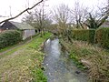
English: Winterborne Kingston is a village in north Dorset, England, situated in a winterbourne valley on the Dorset Downs, seven miles south of Blandford Forum. The village has a population of 613 . The main features of the village are the River Winterborne which flows through it, and the Greyhound Inn (or The Dog as some locals call it), a traditional English pub offering a variety of foods and drink.
village and civil parish in Dorset, UK  | |||||
| Upload media | |||||
| Instance of | |||||
|---|---|---|---|---|---|
| Location | Dorset, South West England, England | ||||
| Said to be the same as | Winterborne Kingston (Wikimedia duplicated page, civil parish) | ||||
 | |||||
Subcategories
This category has the following 3 subcategories, out of 3 total.
W
- Winterborne Muston (4 F)
Media in category "Winterborne Kingston"
The following 102 files are in this category, out of 102 total.
-
 A31 eastbound - geograph.org.uk - 4427208.jpg 640 × 480; 52 KB
-
 Abbot's Court Dairy - geograph.org.uk - 4662221.jpg 1,024 × 768; 174 KB
-
 Abbot's Court Farm - geograph.org.uk - 337624.jpg 640 × 428; 145 KB
-
 Abbots Court Dairy - geograph.org.uk - 5290927.jpg 640 × 427; 52 KB
-
 Approach to Winterbourne Kingston - geograph.org.uk - 2164134.jpg 640 × 480; 101 KB
-
 Barn near Winterborne Kingston - geograph.org.uk - 568806.jpg 640 × 480; 139 KB
-
 Bere Road, Winterborne Kingston - geograph.org.uk - 2614331.jpg 640 × 480; 65 KB
-
 Bridle way to Muston Down - geograph.org.uk - 5290955.jpg 640 × 427; 156 KB
-
 Bridleway approaching Muston Lane - geograph.org.uk - 4690656.jpg 1,024 × 768; 219 KB
-
 Bridleway near Winterborne Kingston - geograph.org.uk - 458063.jpg 640 × 480; 66 KB
-
 Bridleway to Muston Down - geograph.org.uk - 336074.jpg 428 × 640; 170 KB
-
 Bridleway to Winterborne Kingston - geograph.org.uk - 4690654.jpg 1,024 × 768; 261 KB
-
 Bridleway, off Bagwood Road - geograph.org.uk - 2843812.jpg 1,024 × 768; 228 KB
-
 Burning Waste at Munston Field Barn - geograph.org.uk - 5290933.jpg 640 × 427; 81 KB
-
-
 Downland, near to Bere Down Farm, Dorset - geograph.org.uk - 325682.jpg 480 × 640; 125 KB
-
 Dried-up stream, crossing White Lane - geograph.org.uk - 2843805.jpg 1,024 × 768; 406 KB
-
 Duck Street, Winterborne Kingston - geograph.org.uk - 3087471.jpg 640 × 480; 80 KB
-
 Duck Street, Winterbourne Kingston - geograph.org.uk - 2614291.jpg 640 × 480; 78 KB
-
 Entrance to Winterborne Kingston - geograph.org.uk - 3087466.jpg 640 × 480; 71 KB
-
 Field by the A31 - geograph.org.uk - 569117.jpg 640 × 437; 80 KB
-
 Field Near Muston Field Barn - geograph.org.uk - 5290949.jpg 640 × 427; 61 KB
-
 Field on Muston Down - geograph.org.uk - 5290973.jpg 640 × 427; 79 KB
-
 Fields at Winterborne Kingston - geograph.org.uk - 3341279.jpg 640 × 480; 98 KB
-
 Fields Near Hill Barn - geograph.org.uk - 5290969.jpg 640 × 427; 54 KB
-
 Fields near Lincoln Farm - geograph.org.uk - 2787820.jpg 640 × 480; 78 KB
-
 Fields near Winterborne Kingston - geograph.org.uk - 2787750.jpg 640 × 480; 89 KB
-
 Footpath - geograph.org.uk - 336121.jpg 640 × 428; 118 KB
-
 Footpath to Winterborne Muston - geograph.org.uk - 4690653.jpg 1,024 × 768; 181 KB
-
-
 Griffith's Pit - geograph.org.uk - 569291.jpg 640 × 480; 128 KB
-
 Hay Storage Barns - geograph.org.uk - 3341304.jpg 640 × 480; 60 KB
-
 Junction Winterborne Muston - geograph.org.uk - 2614368.jpg 640 × 480; 92 KB
-
 Marsh Lane near Winterborne Kingston - geograph.org.uk - 2614351.jpg 640 × 458; 61 KB
-
 Marsh Lane, Winterborne Muston - geograph.org.uk - 2614373.jpg 640 × 480; 64 KB
-
 Muston Farm, Winterborne Muston - geograph.org.uk - 4662217.jpg 1,024 × 768; 242 KB
-
 Muston Lane - geograph.org.uk - 336005.jpg 640 × 428; 118 KB
-
 Muston Lane - geograph.org.uk - 5351138.jpg 640 × 428; 131 KB
-
 New Barn on Muston Down - geograph.org.uk - 5290941.jpg 640 × 427; 83 KB
-
 Nutley Clump - geograph.org.uk - 3341288.jpg 640 × 480; 110 KB
-

-

-
 Overgrown path - geograph.org.uk - 569275.jpg 640 × 480; 175 KB
-
 Road across North Down - geograph.org.uk - 3340319.jpg 640 × 480; 99 KB
-
 Road north of Winterborne Kingston - geograph.org.uk - 3087479.jpg 640 × 480; 45 KB
-
 Road north of Winterborne Kingston - geograph.org.uk - 3087485.jpg 640 × 480; 41 KB
-
 Road north of Winterborne Kingston - geograph.org.uk - 568810.jpg 640 × 480; 135 KB
-
 Road out of Winterborne Kingston - geograph.org.uk - 3340310.jpg 640 × 480; 82 KB
-
 Road south of Winterborne Kingston - geograph.org.uk - 2460495.jpg 640 × 480; 52 KB
-

-
 Road south of Winterbourne Kingston - geograph.org.uk - 2614318.jpg 640 × 480; 78 KB
-
 Road west from Winterborne Kingston - geograph.org.uk - 5351148.jpg 640 × 428; 85 KB
-
 Road west from Winterborne Kingston - geograph.org.uk - 5351155.jpg 640 × 480; 93 KB
-
 Roadside Snowdrops - geograph.org.uk - 5290923.jpg 640 × 480; 151 KB
-
 Sackville Street, Winterbourne Kingston - geograph.org.uk - 3099585.jpg 1,024 × 768; 148 KB
-
 Sheds at Muston Farm - geograph.org.uk - 4690638.jpg 1,024 × 768; 147 KB
-
 Spindle-tree berries - geograph.org.uk - 569257.jpg 487 × 640; 99 KB
-
 Stubble field and Abbot's Court Farm - geograph.org.uk - 4690651.jpg 1,024 × 768; 266 KB
-

-
 The Dunbury School, Winterborne Kingston - geograph.org.uk - 458052.jpg 640 × 480; 109 KB
-

-
 The River Winterborne - geograph.org.uk - 4690633.jpg 1,024 × 768; 276 KB
-
 The village school, Winterbourne Kingston - geograph.org.uk - 3099626.jpg 1,024 × 766; 238 KB
-
 Track and bridle path - geograph.org.uk - 1531335.jpg 640 × 453; 128 KB
-
 Track at Muston Field Barn - geograph.org.uk - 5290939.jpg 640 × 427; 88 KB
-
 Tumulus on West Down - geograph.org.uk - 2843936.jpg 1,600 × 1,200; 477 KB
-
 Village Hall, Winterborne Kingston - geograph.org.uk - 457967.jpg 640 × 480; 86 KB
-
 Village school, Winterbourne Kingston - geograph.org.uk - 3099612.jpg 1,024 × 763; 197 KB
-

-
 West Down near Winterborne Kingston - geograph.org.uk - 1531305.jpg 640 × 375; 36 KB
-
 West St, Winterborne kingston - geograph.org.uk - 1531331.jpg 640 × 529; 113 KB
-
 West St, Winterborne Kingston. - geograph.org.uk - 1531330.jpg 640 × 489; 102 KB
-
 Winterborne Kingston - geograph.org.uk - 1531329.jpg 640 × 474; 73 KB
-
 Winterborne Kingston - geograph.org.uk - 163281.jpg 600 × 450; 82 KB
-

-
 Winterborne Kingston, bridleways - geograph.org.uk - 1374318.jpg 640 × 480; 113 KB
-

-
 Winterborne Kingston, Dunbury School - geograph.org.uk - 1373738.jpg 640 × 480; 86 KB
-
 Winterborne Kingston, old chapel - geograph.org.uk - 1373675.jpg 640 × 480; 94 KB
-
 Winterborne Kingston, post office - geograph.org.uk - 975026.jpg 640 × 480; 89 KB
-

-
 Winterborne Kingston, River Winterborne - geograph.org.uk - 3348199.jpg 1,024 × 768; 288 KB
-
 Winterborne Kingston, Roman road - geograph.org.uk - 1374247.jpg 640 × 480; 100 KB
-
 Winterborne Kingston, village hall - geograph.org.uk - 1373719.jpg 640 × 480; 83 KB
-

-
 Winterborne Kingston, war memorial - geograph.org.uk - 1373703.jpg 640 × 480; 81 KB
-
 Winterborne Kingston, Winterborne River - geograph.org.uk - 1373759.jpg 640 × 480; 124 KB
-
 Yew Tree, St Nicholas Church - geograph.org.uk - 2239754.jpg 640 × 480; 90 KB
-
 After the Rain - geograph.org.uk - 337612.jpg 428 × 640; 133 KB
-
 Along the Roman Road - geograph.org.uk - 336910.jpg 640 × 428; 144 KB
-
 Country Store, Winterborne Kingston - geograph.org.uk - 163283.jpg 600 × 450; 58 KB
-
 Dorset Farmland - geograph.org.uk - 336092.jpg 640 × 428; 42 KB
-
 First Shoots - geograph.org.uk - 336917.jpg 640 × 428; 112 KB
-
 Goschen - geograph.org.uk - 336018.jpg 640 × 428; 113 KB
-

-
 On Muston Down - geograph.org.uk - 338521.jpg 640 × 428; 111 KB
-
 Ploughed Field - geograph.org.uk - 336038.jpg 640 × 428; 107 KB
-
 Ready for Sowing - geograph.org.uk - 336904.jpg 640 × 428; 111 KB
-
 Red Post, Winterborne Anderson - geograph.org.uk - 163277.jpg 600 × 450; 85 KB
-
 Roman Road - geograph.org.uk - 335994.jpg 640 × 428; 106 KB
-
 Tree lined stream - geograph.org.uk - 336129.jpg 428 × 640; 148 KB
-
 View towards Hill Barn - geograph.org.uk - 336921.jpg 640 × 428; 130 KB


